Ñaupahuasi
Ñaupauasi is an Inca (I think) village above the city of Yauyos, Peru. These Inca Terraces run for miles up the valley along the Yauyos river. Some are preserved and some are in ruins. These are some of the preserved and still used terraces. These are mostly used for growing alfalfa for the cows in Yauyos, but behind the fence to the left someone is growing flowers.
Here you can see walls of the homes in Ñaupahausi. I could not find anything in the Internet on this city. There are no trails to it any only one vague sign (at the end of this blog), although the tourist materials published by the district of Yauyos do mention it several times as one of the important attractions of this district.
In these three images you can see the keystones and riprap method of construction.

The hillside is covered with stones with flat sides. They probably picked up stone after stone until they found ones that fit. They also used mud, if not as a mortar then to keep out the winds and the cold. Yauyos is about 1,000 feet lower and it is at 9,429 feet above sea level, so Ñaupahausi is definitely over 10,000 feet, maybe 11,000.
Views from the top. Below is the valley of the Yauyos river. As far as you see in this picture there were hillsides terraced by the Incas. On the other side is the Valley of the Cañete river. This town is protected by steep hillside and cliffs.
This is the only stone I found that looked painted. Maybe it is or maybe not.
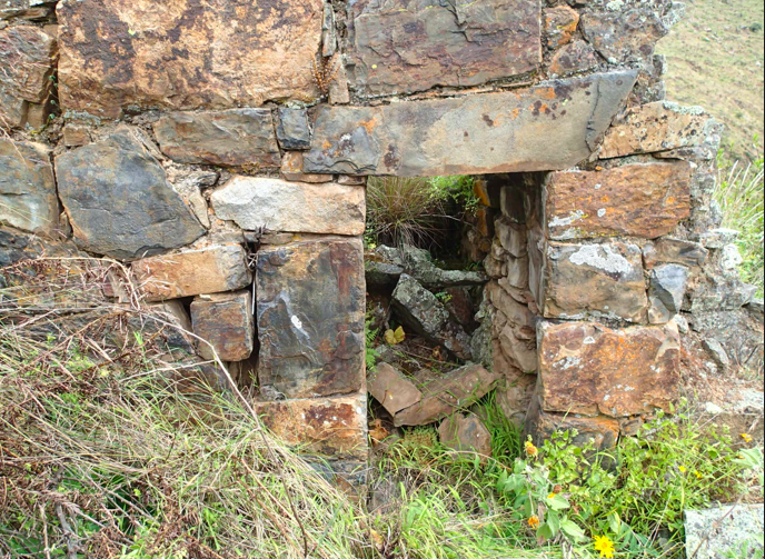
This is my favorite picture. Look at the stones that are turned to provide shelves, the small hole to perhaps provided light. This is the second ruin in Peru that I have visited and found such expressions of love and family life. In the other, reconstructed ruins I have visited in Peru this personal expression seems to be missing.
These two photos show the beautiful moss covered walls. Some also had ferns and flowers growing from them.

The town of Yauyos way down there by the river of Yauyos. The route to Ñaupahausi is: from the town square, cross the bridge continue on the same street and follow the trail up the hill for about 2-3 hours. You will pass a couple of houses and get to a circle. There are about 3-4 houses near that circle, continue up the road that leaves from the circle. At some point that road goes to the right, the road to the right is the Inca Trail to a different ruin. You want to go left and up, there is no trail so scramble, bushwhack, wade, or whatever you need to do to get to the ruins, which you can see above you.
 |
| The mountain above Yauyos |
 Yes, I really was there.
A patch of corn grown by the road. This shows present day agriculture with all its erosion problems.
This is the "map" that is at the very end of the road that goes up the
hill. I found it at the very end of my trek from the ruins.


No comments:
Post a Comment